
Soil sampling design: how many samples do you actually need?
Stratified sampling divides land into zones likely to behave similarly in soil organic carbon, so each sample carries more information and fewer are needed for the same statistical confidence. Sample count follows from the confidence level and the minimum detectable difference the applicable standard requires, so it is design-specific rather than a fixed ratio. Across monitored pilots and projects, counts have averaged about one sample per 16 hectares against European standard practice of one per five to seven.
What stratification is
A field is not uniform. Soil organic carbon varies with texture, drainage, slope position, historic management and a dozen other factors, and that variation is largely structured rather than random. Two points in the same low-lying clay hollow will resemble each other far more than either resembles a point on the sandy rise thirty metres away.
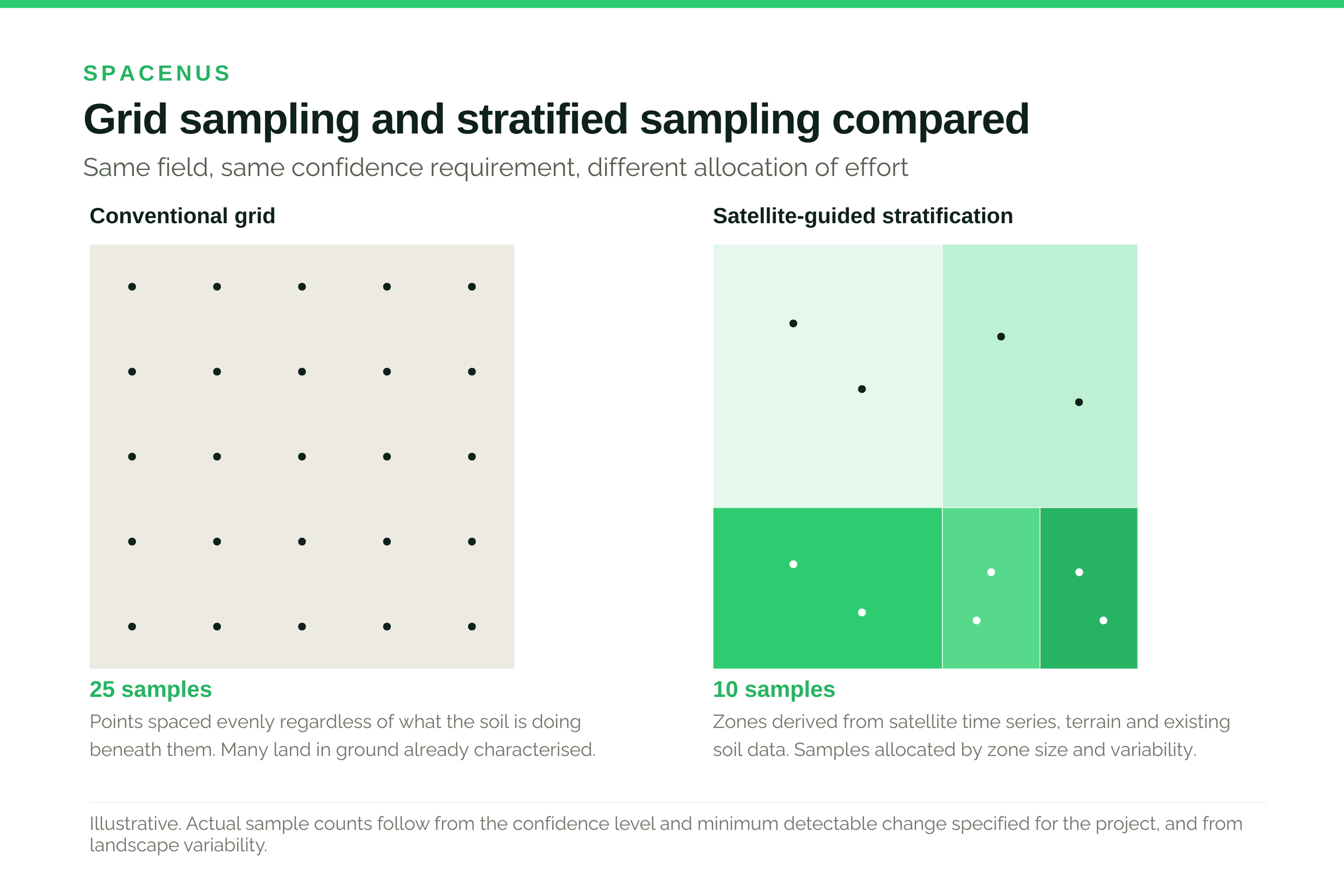
Grid sampling ignores this. It places points at even intervals across the map, which means a large share of them land in ground that behaves like ground already sampled. Those samples cost money and add little.
Stratification uses satellite time series, terrain models and existing soil data to divide the area into zones expected to behave similarly, then allocates samples across zones in proportion to how variable and how large each one is. The same statistical confidence is reached with fewer physical cores.
How far can sample counts fall
This is where the market gets confusing, because several numbers circulate and they are routinely quoted as if interchangeable. They are not. Each describes a different method under different conditions.
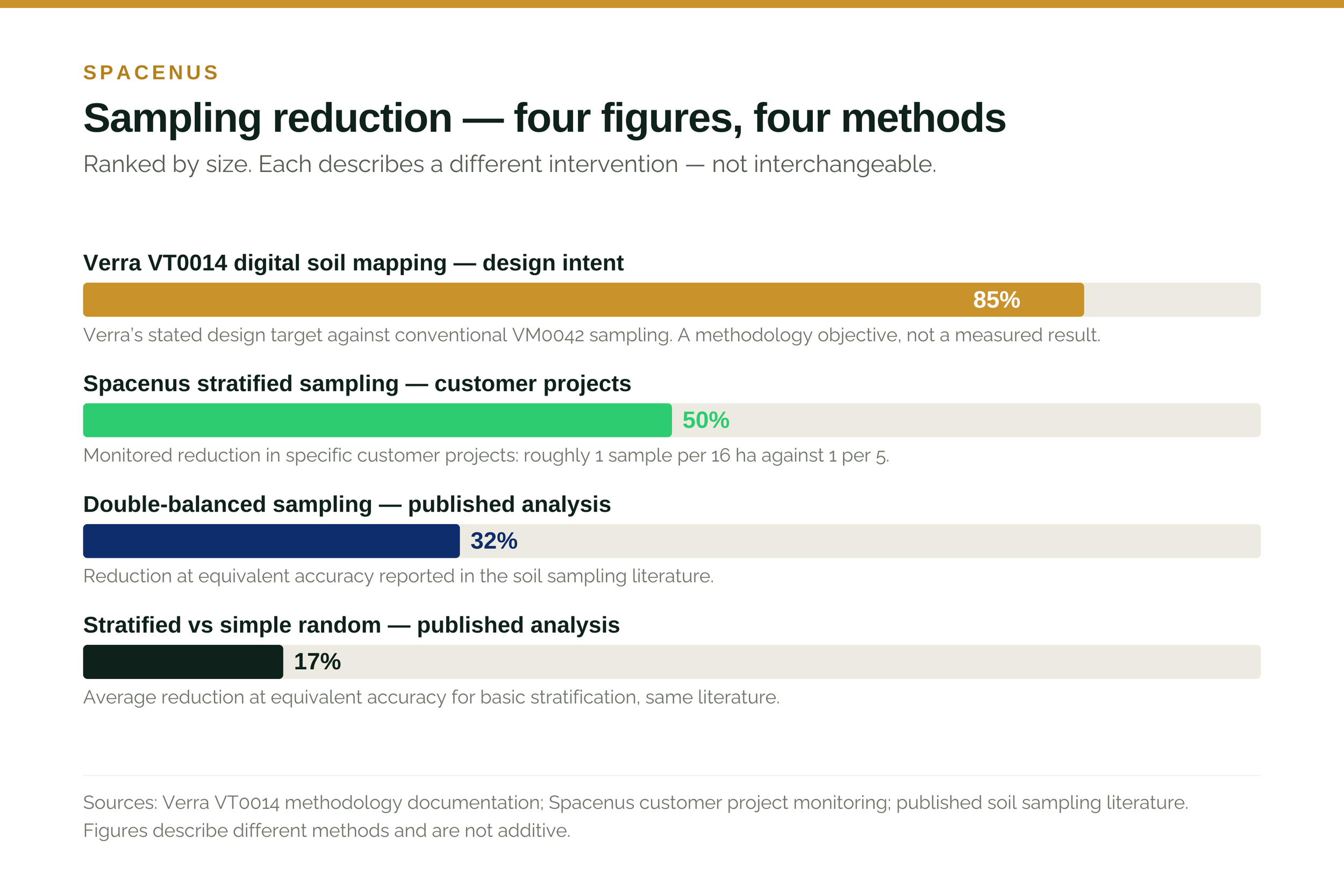
Published comparisons of sampling design report that basic stratification reduces the number of samples needed by roughly 17% at equivalent accuracy against simple random sampling, and that more sophisticated double-balanced designs reach around 32%. These are controlled methodological comparisons, and they are the conservative end of the range.
In specific Spacenus customer projects we monitor a reduction of about 50% in sampling density — roughly one sample per 16 hectares against a conventional one per five. That is a project-level operational figure from particular landscapes, not a universal claim.
Verra designed VT0014 to reduce physical sampling by considerably more again, because digital soil mapping changes the role of the sample from measurement to model validation. That is a methodology design objective rather than a measured field result.
If you are comparing providers, insist on knowing which of these three a quoted number belongs to. A figure detached from its method and its landscape is not information.
Why accuracy does not have to fall
The intuition that fewer samples must mean a worse estimate is reasonable and, in this case, wrong — provided the zones are correct.
The uncertainty of an estimate depends on the variance within the population being sampled. If you split a heterogeneous field into zones that are each internally consistent, the variance within each zone is small, so fewer samples per zone are needed to characterise it. Total uncertainty across the field can be equal to or lower than a grid design using more samples.
The condition is that the zones actually correspond to real soil behaviour. If the stratification is wrong — if the satellite signal is picking up something other than what drives carbon variation in that landscape — then the design fails, and it fails invisibly. This is the genuine risk in the method, and it is why validation samples exist.
“The zones are the product. Everything else follows from whether they are right, which is why we validate them rather than asserting them.” — Spacenus agronomy team
What it is worth
Sampling is not the whole cost of verification, but it is the part that scales with area and repeats every measurement cycle. Reducing it changes what size of programme is viable.
In the ESA SatMRV programme, verification across 8,845 hectares of European arable farmland came to 4.1% of projected credit revenue, against a conventional range of 25–50%. Sampling design is a substantial part of that difference — alongside processing speed and the share of area that could be verified without new physical samples.
There is a second benefit that projects tend to undervalue. A stratified design produces a zone map, and that map has agronomic uses beyond the carbon calculation: variable-rate planning, field prioritisation, understanding why one part of a field consistently underperforms. Projects that treat it purely as a compliance artefact discard something they have already paid for.
Where the carbon actually is
A note on scale, because it is frequently mangled. Soils hold more carbon than the atmosphere and terrestrial vegetation combined. Sanderman and colleagues estimated that agriculture has released roughly 133 gigatonnes of carbon from soils over approximately twelve thousand years of cultivation — a long accumulation, not an industrial-era event.
That figure is often quoted as though it were recent and therefore quickly reversible. It is neither. Rebuilding even part of it is a multi-decade undertaking, and the reason measurement matters is that nobody will pay for a change they cannot see.
What to ask a provider
What data drives the stratification in my landscape, and has that relationship been validated locally rather than assumed from elsewhere?
What confidence level and minimum detectable change is the sample count derived from? The count should follow from the requirement, not the other way round.
How is uncertainty quantified and reported, and will that documentation satisfy the registry or assurance provider I have to answer to?
What happens when validation samples disagree with the model? A provider without a clear answer has not thought about the failure mode.
Spacenus designs stratified sampling as part of SatMRV, for programmes operated by others. We do not issue credits and have no stake in whether a field passes, which is the point. If you want to know what a stratified design would look like on your fields, we will produce one before you commit to anything.
Common questions
Does stratified sampling satisfy Verra VM0042?
Stratified sampling design is an accepted approach under VM0042 and compatible with EU CRCF verification requirements. What the standards require is statistical validity at a stated confidence level, not a prescribed number of samples.
How many samples will my project need?
It follows from the confidence level and minimum detectable change you specify, the variability of the landscape, and how much existing soil data covers the region. Any provider quoting a sample count before knowing those three things is guessing.
What if the zones are wrong?
That is the real risk, and it is why validation samples are held back and tested against the model rather than folded into it. A design that cannot be checked should not be trusted.
Can stratification reduce fertiliser use as well?
The same zone map supports variable-rate application, which is a separate benefit from the carbon measurement. Whether it reduces total input depends on the field and the current practice, so we would rather not put a number on it here.