
10 YEARS · ESA & BMBF FUNDED · ALL IP OWNED BY SPACENUS
Ten years of satellite science. Built for assurance-grade agricultural verification.
Spacenus verification rests on three technical foundations. RothC soil organic carbon modelling calibrated against physical samples. A deep-learning fusion of Sentinel-1 radar and Sentinel-2 optical imagery that produces cloud-free vegetation time series above 90% precision. And a four-stream Triangulation Verification Methodology combining plausibility pre-screening, satellite time series, verified ground evidence and spatial cross-validation using Dempster–Shafer evidence fusion, so that conflict between streams is treated as signal rather than averaged away. Uncertainty is quantified at the level of each claim.
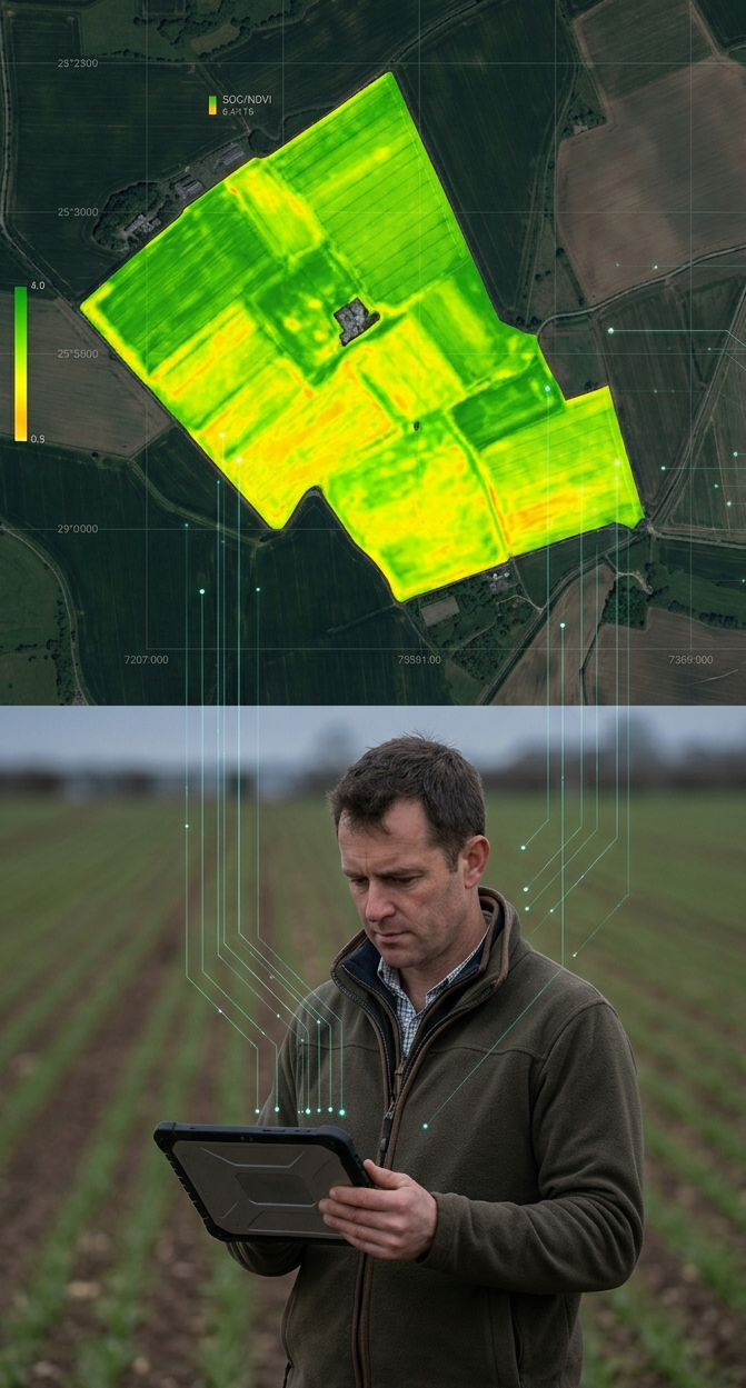
CORE TECHNOLOGY ASSETS
7 technology assets. One platform. Every module - PDCT, ANA, SatMRV, RegenScope3 - runs on this stack.
Satellite Calibration Engine (ANA Core)
ESA DASF 2018–2020 · ESA SIITAg 2021–2023
Smartphone photo + GPS + Sentinel-2 fusion converts relative satellite indices into absolute nutrient values (kg/ha). Technical first for precision nitrogen in Europe, Americas & Asia. Foundation for all NUE recommendations and the triangulation verification layer.
SatMRV SOC Engine
ESA BASS SatMRV Programme 2023–2025
RothC-based soil organic carbon modelling combined with stratified sampling design and Sentinel-2 time series. Processes 100 ha fields in under one minute. Reduces sampling density by 50% vs. standard protocols.
Field Boundary & Crop Type Detection
ESA GFaaS 2017–2018
AI-based satellite detection and enhancement of millions of field boundaries for Germany and Europe. Enables onboarding without farmer manual data entry. Foundation for all field-level analytics.
Get Data (Independent Data Pipeline)
Built and extended continuously since 2015
Serverless harvesting and geo-processing pipeline that acquires satellite imagery and companion geospatial data (terrain, soil, land use, gridded weather) directly from root sources and renders it analysis-ready the evidence chain never routes through a third-party aggregator Spacenus cannot audit, reproduce, or control.
FUSION Model - Cloud-Penetrating AI
Hessen Distr@l FUSION Project 2023–2025
Deep learning model fusing Sentinel-1 SAR radar + Sentinel-2 optical data to produce cloud-free NDVI and biomass time series at >90% precision. Solves the biggest reliability problem in satellite MRV: cloud cover over European winters and South Asian monsoon seasons.
Triangulated Verification Architecture (TVM)
ESA SIITAg 2021–2023 · ESA ReCotton 2025–2026
Four-stream TVM: satellite time-series classification + verified geotagged photos + spatial cross-validation against regional baseline + plausibility pre-screening = cryptographically signed Digital Proof of Practice certificate (DPP).
Platform - Geospatial Framework as a Service
ESA Kick-Start 2017–2018
Cloud-based EO data processing platform connecting satellite & other geospatial data to agricultural applications via API. Infrastructure backbone enabling API service delivery to AgTech partners globally.
See how these assets power our products → SatMRV | RegenScope3 | ANA
FEATURED CAPABILITY - FUSION
FUSION: All-weather satellite intelligence, cloud-free field monitoring, all-year.
Our FUSION model fuses Sentinel-1 SAR radar with Sentinel-2 optical data using deep learning. The result is cloud-penetrating, all-weather field intelligence with >90% NDVI precision. This is the critical enabler for reliable MRV in South Asian and tropical geographies - regions where cloud cover would otherwise make satellite-based verification impossible for 4–6 months per year.
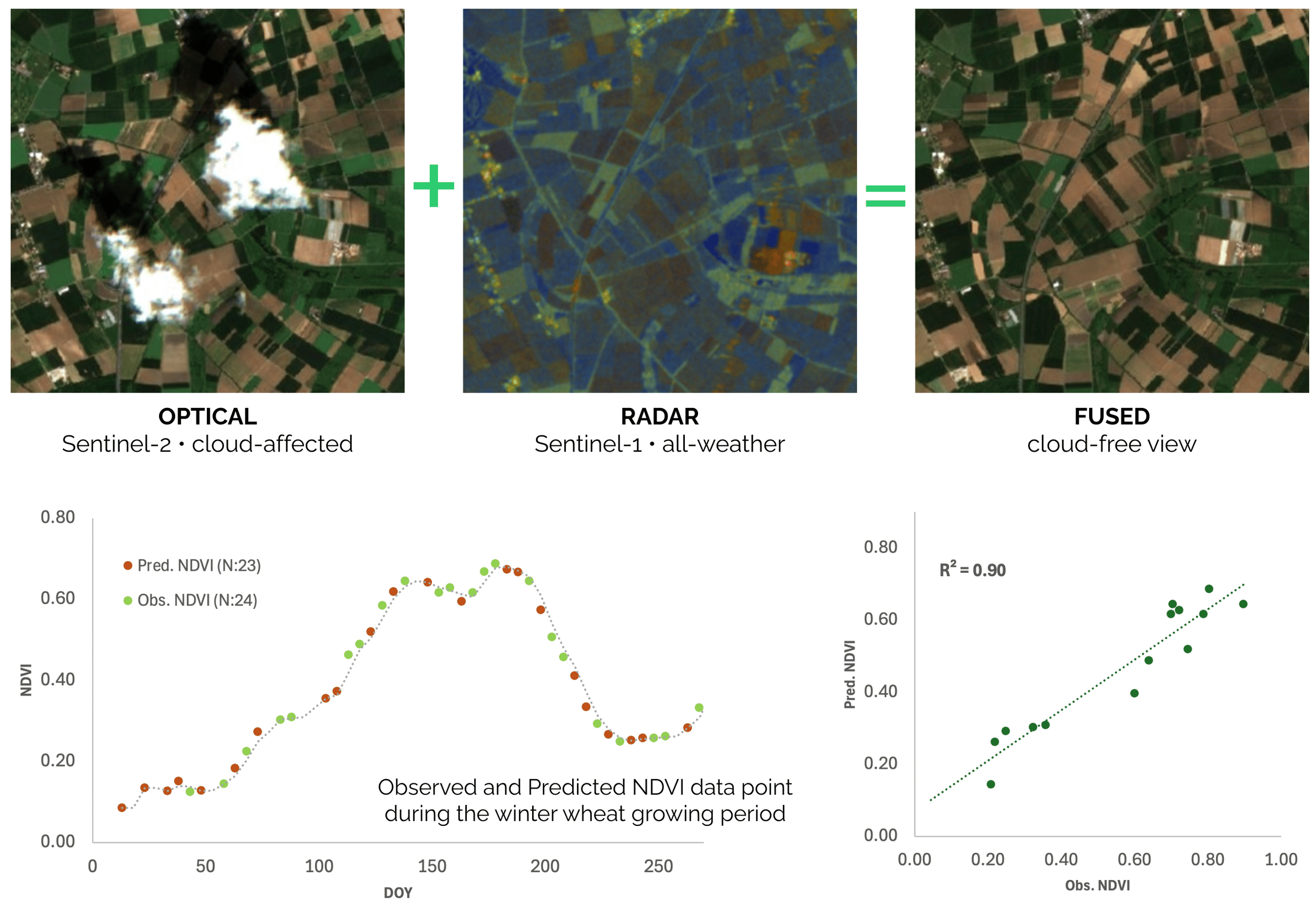
Origin: Distr@l FUSION Project (April 2023 – March 2025)
FEATURED CAPABILITY - TVM
TVM: Four independent streams. One calibrated confidence score. One audit-ready Digital Proof of Practice.
Our Triangulation Verification Methodology integrates four independent evidence streams - satellite time-series, verified field photos, spatial cross-validation, and plausibility pre-screening, into a single confidence-weighted verification engine. Evidence is fused using Dempster–Shafer Theory: missing data contributes genuine uncertainty, not a zero. When streams conflict, the conflict itself is the signal, not a score to be averaged away. High-confidence fields receive a cryptographically signed Digital Proof of Practice (DPP) certificate. Fields with fraud signals are escalated immediately.
The result is a verification system that is honest about what it knows, what it doesn't, and when human review is required. Already recognised and deployed by a major international standard body across farms globally.
4
independent evidence streams — no single point of manipulation
94%
of enrolled fields issued DPP certificate in first verification cycle
10
years immutable audit trail retention per field
FEATURED CAPABILITY - GET DATA: THE INDEPENDENT DATA PIPELINE
GET DATA: One independent data pipeline, from the root source to the audit trail.
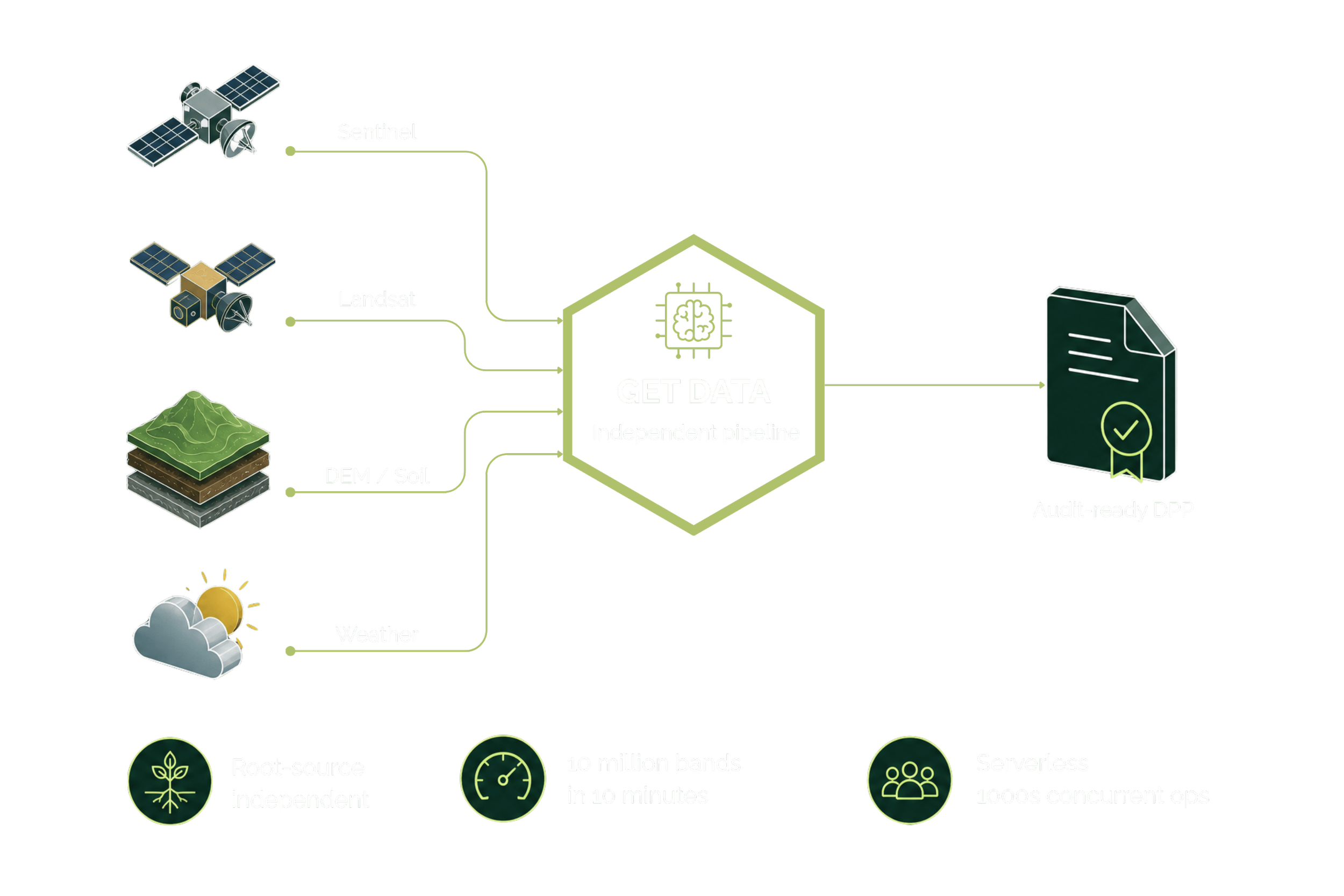
Get Data harvests satellite imagery alongside other geospatial data like terrain, soil, land-use, and gridded weather data etc. directly from their root sources, then runs the geo-processing that makes them analysis-ready. We do not build on a third-party data platform: an evidence chain that routes through an external aggregator carries dependencies we cannot audit, reproduce, or control. By owning the pipeline end to end, we keep our verification reproducible, our costs lean, and our DPP tamper-resistant from the data up. Built continuously since 2015, it runs serverless and harvests close to 10 million satellite data bands (spectral layers) in 10 minutes, the throughput independent verification at supply-chain scale requires.
Built for the standards that count. Ready for the mandates arriving in 2027.
Registry & Compliance Standards
Verra VM0042 (SOC) · EU CRCF (aligned) · GHG Protocol LSR Standard (primary data, Jan 2027) · Gold Standard · Verra VM0051 (rice, in development)
Reporting Frameworks
CSRD ESRS E1 (climate/Scope 3) · ESRS E3 (water) · ESRS E4 (biodiversity) · SBTi FLAG v1.2 · EU EmpCo · GHG Protocol Supply Chain Standard
The IAASB’s global sustainability-assurance standard applies to engagements for periods beginning 15 December 2026. DPP evidence packs are built for ISSA 5000-grade reliance: documented methodology, quantified uncertainty, reproducible results, immutable ten-year trail.
This is not science for its own sake. Every technology asset on this page, from the FUSION cloud-penetrating model to the RothC SOC engine, exists to produce one thing: a verification result that holds under audit, in any registry, in any jurisdiction. That is what our clients require. That is what we deliver.
Want to understand the methodology in depth?
Request our technical methodology brief or book a call with our science team.
-
Every reported figure carries uncertainty stated at the level at which the claim is made, because uncertainty is an eligibility condition under CRCF and GHG Protocol LSR rather than a footnote. Where evidence streams disagree, Dempster–Shafer fusion treats the conflict as signal rather than averaging it away, and missing data contributes genuine uncertainty rather than a zero.
-
Soil organic carbon stock is not directly observable from orbit. Bulk density and equivalent soil mass require physical measurement. Fertiliser application is not remotely observable. Model transferability degrades outside the calibration range. Satellite data determines where to sample and monitors change between sampling rounds. It does not replace the samples.
-
Spacenus appears on the author list of a cloud-removal paper in the European Journal of Agronomy, volume 161 (2024), article 127333. Two further papers, on RothC validation and on the TVM methodology, are in preparation. Spacenus makes no claims about either until they are submitted.