
Audit coverage and continuous monitoring: closing the gap
Supply chain audit programmes visit a sample of farms, so any claim covering the whole supply base is partly an extrapolation from the farms nobody visited. Continuous satellite monitoring closes that coverage gap and shortens detection time, and it works best as capacity relief for verification bodies rather than as a replacement for them. It cannot quantify soil organic carbon, observe fertiliser application, or substitute for accredited professional judgement.
What sample auditing actually verifies
The physical farm audit has been the gold standard of agricultural sustainability verification for thirty years, and on its own terms it is rigorous. A trained assessor visits, walks the fields, reviews records, talks to the farmer and issues a certificate. The problem is not the quality of the visit. It is how few visits there are.
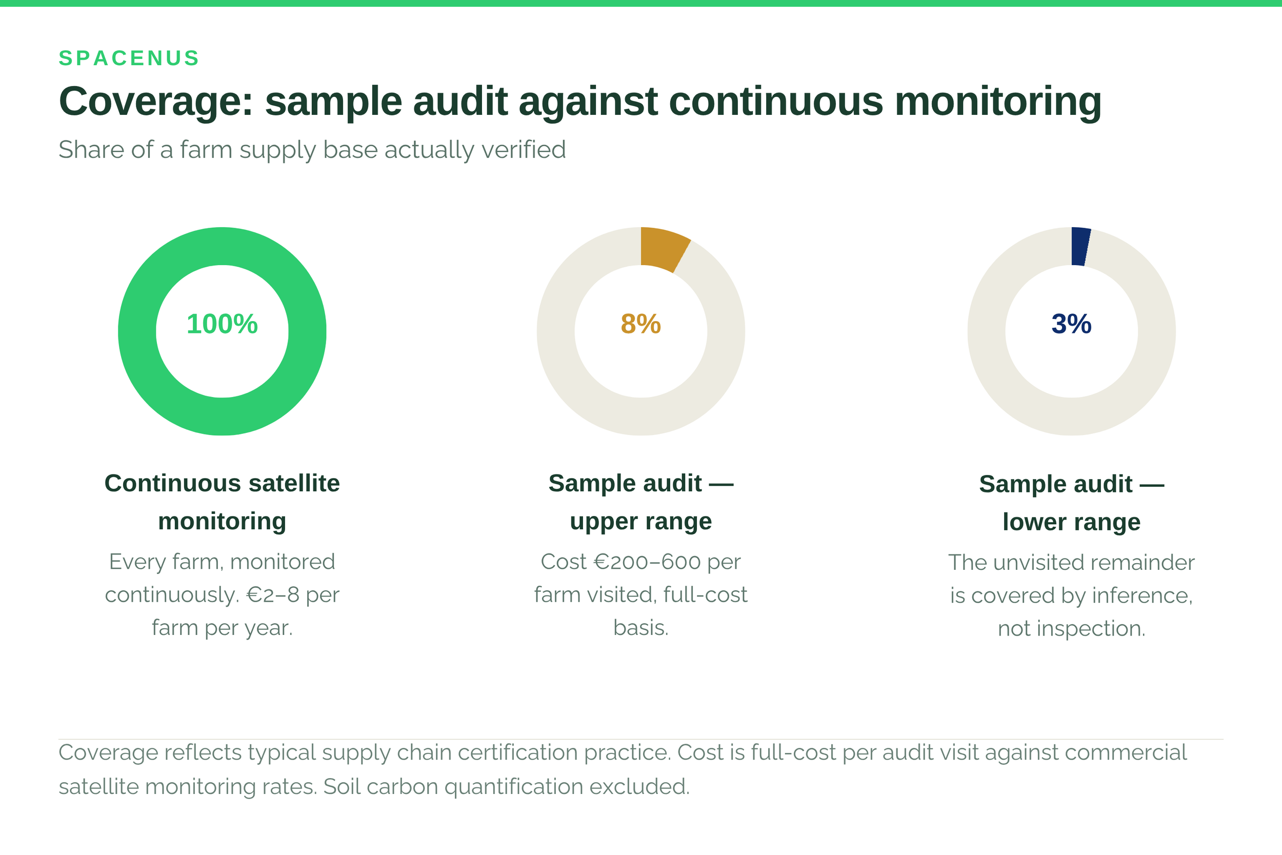
Selection is usually risk-based, which is sensible and does not solve the arithmetic. Verification covering 5% of a supply chain verifies 5% of it. Everything else is inference from a small and possibly unrepresentative sample, and that inference sits underneath CSRD disclosures, SBTi submissions and consumer-facing claims.
The event a quarterly audit cannot see
Consider a concrete case. Five hundred hectares of primary forest cleared for soy in a Brazilian supply region can be cleared and replanted within about six weeks. A quarterly sample audit misses it completely — not through negligence, but because the evidence has been removed before anyone arrives.
Daily satellite revisit detects the vegetation change within 24 hours. This is not hypothetical: deforestation events linked to major food supply chains have been documented by satellite monitoring organisations in regions simultaneously certified deforestation-free under conventional audit programmes. The satellite saw what the auditor did not visit.
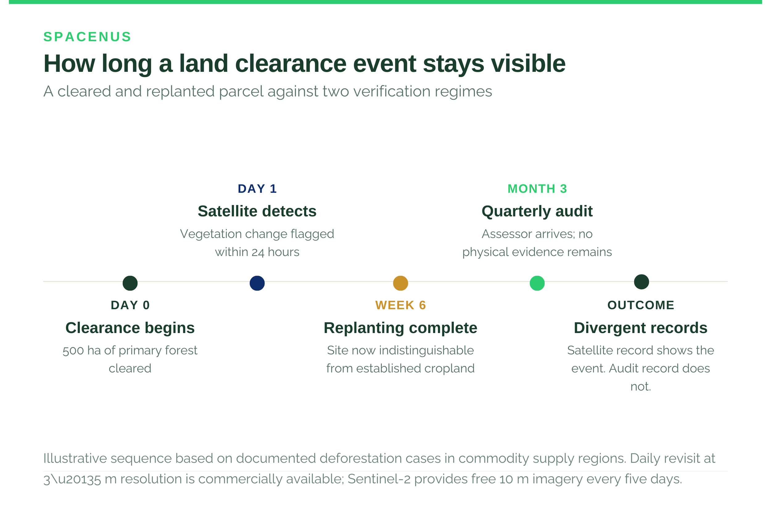
The capability is not speculative. Planet Labs operates a constellation revisiting any point on Earth at 3–5 metre resolution daily. ESA’s Sentinel-2 provides free public imagery at 10 metres every five days. Models trained on these datasets verify cover crop presence and timing, tillage method, land use change, rotation compliance and drought or flood stress at field level.
The cost comparison
A full-cost manual audit visit - travel, preparation, time on farm, report production, quality review - runs roughly €200–600 per farm. Continuous satellite monitoring of the same farm for a year costs in the region of €2–8 at current commercial rates.
A company that could previously afford to verify 5% of its supply base can verify all of it, for less total spend. That is not a product improvement. It changes what verified evidence is able to look like.
“At €8 per farm per year, full-coverage verification stops being a technology question and becomes a procurement decision.” — Spacenus team
Where satellite alone is not enough
One qualification matters, and providers who skip it should be treated with caution.
Soil carbon quantification at the precision required for high-integrity carbon programmes, Verra VM0042 and equivalents, is not resolved by satellite alone. Bulk density and equivalent soil mass need physical measurement, and models need local calibration samples. Satellite reduces how many are needed and changes what they are for; it does not remove them.
For most of what a food company must verify under CSRD, EUDR and the Green Claims regime, though, the technology is already sufficient. Land use change, practice occurrence, timing and spatial extent are exactly what satellite does well.
Is the assurance community ready
Moving in that direction, cautiously. Verra’s VM0042 incorporates satellite monitoring for land use baseline assessment. EUDR due diligence can be satisfied with geo-referenced satellite analysis combined with company traceability data. CSRD ESRS E4 biodiversity guidance references remote sensing as an acceptable evidence source.
What has not yet moved is the assurance profession. Sustainability-linked finance and CSRD engagements still largely expect human-signed verification, and standard bodies have not shifted to certifying the algorithm rather than inspecting the farm. That transition needs a body of validated evidence - published accuracy studies, side-by-side comparison with manual audit results, which the remote sensing community is still assembling.
ISSA 5000, effective December 2026, will make assurance providers more consistent and more demanding about evidence quality. That cuts both ways: it raises the bar on weak agricultural data, and it rewards evidence that can actually be tested.
What to do with this
Establish what share of your supply base is currently visited, and state it internally. Most organisations have never written the number down.
Separate what genuinely needs a person on the farm from what does not. Soil sampling and social conditions do. Land use change and practice timing largely do not.
Treat full coverage as the baseline rather than the ambition. Once monitoring costs single-digit euros per farm, partial coverage is a choice.
Ask your assurance provider what evidence they will accept, now, in writing. The answer is changing and you want to be early to it.
Spacenus provides continuous satellite verification for programmes and supply chains operated by others. We do not issue credits and do not run farmer programmes, so we have no interest in what any particular field turns out to show. Where a claim needs a physical sample, we will tell you.
Common questions
What share of farms does a typical supply chain audit programme visit?
Most programmes sample in the region of 3–8% of farms annually, selected on risk, commodity and geography. The remainder are covered by inference rather than inspection.
Can satellite monitoring replace physical audits entirely?
No. It replaces the coverage function and is far better at it. Soil sampling, bulk density measurement and anything concerning labour or social conditions still require a person present.
Do regulators accept satellite evidence?
Increasingly, for specific purposes. Verra VM0042 uses it for land use baselines, EUDR due diligence can be met with geo-referenced analysis, and CSRD ESRS E4 guidance references remote sensing. Full acceptance across assurance practice is not yet there.
What does continuous monitoring cost per farm?
Roughly €2–8 per farm per year at current commercial rates for practice and land use monitoring, against €200–600 for a single full-cost audit visit. Soil carbon quantification costs more because it requires physical sampling.