
The cloud cover problem, and what SAR-optical fusion can and cannot fix
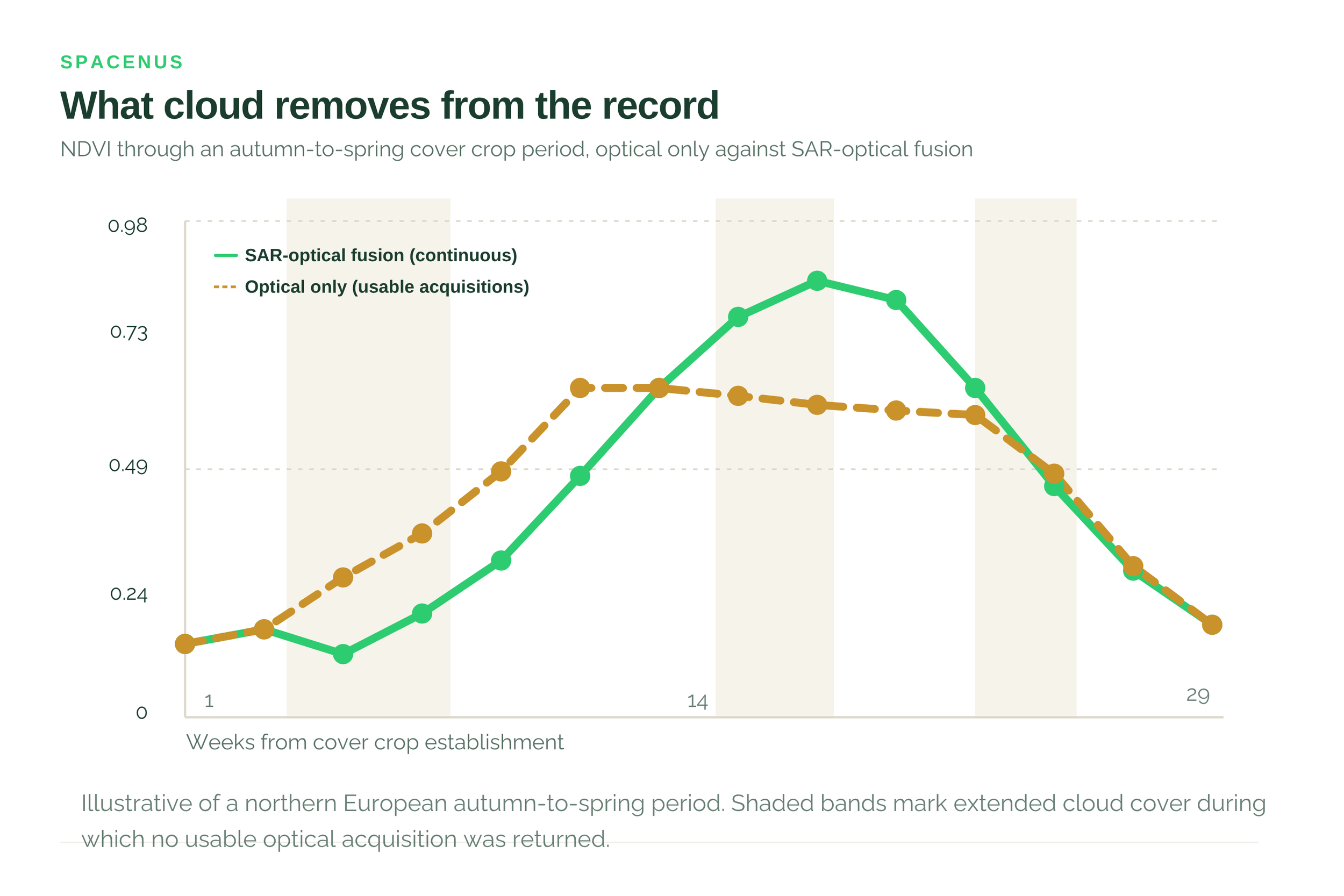
Optical satellites cannot see through cloud, which in northern Europe removes months of the growing season exactly when cover crop and tillage decisions are made. Fusing Sentinel-1 radar, which penetrates cloud, with Sentinel-2 optical restores a continuous vegetation time series at above 90% NDVI precision, validated against withheld clear-sky observations. Fused values are estimates carrying quantified uncertainty rather than measurements, and should always be reported as such.
The gap nobody mentions in the brochure
Optical satellites measure reflected sunlight. Cloud reflects sunlight. The result is that a large share of scheduled acquisitions over temperate and tropical agriculture return nothing usable, and the loss is not evenly distributed, it concentrates in exactly the seasons with the most cloud.
For a farmer this means a monitoring service that works well in June and disappears in November. For anyone verifying a practice claim it is more serious: cover cropping and tillage timing are established in the autumn and winter, and an evidence base with a four-month hole cannot confirm what happened during it.
Why radar is different
Synthetic aperture radar transmits its own microwave signal and measures what returns. Microwaves at Sentinel-1 wavelengths pass through cloud, and because the sensor supplies its own illumination it works at night. Acquisition is unaffected by weather in any practical sense.
The catch is that radar does not measure the same thing. Optical sensors respond to leaf pigment and chlorophyll, which is what NDVI is built on. Radar responds to structure, geometry and water content. A radar backscatter value tells you something real about the canopy, but it is not a vegetation index and cannot be substituted for one.
So the problem is not availability. It is translation.
What fusion does
Fusion trains a model on periods when both sensors observed the same field, learning the relationship between radar backscatter and the optical vegetation index for that crop, that growth stage and that landscape. Once that relationship is established, radar observations during cloudy periods can be used to estimate what the optical sensor would have seen.
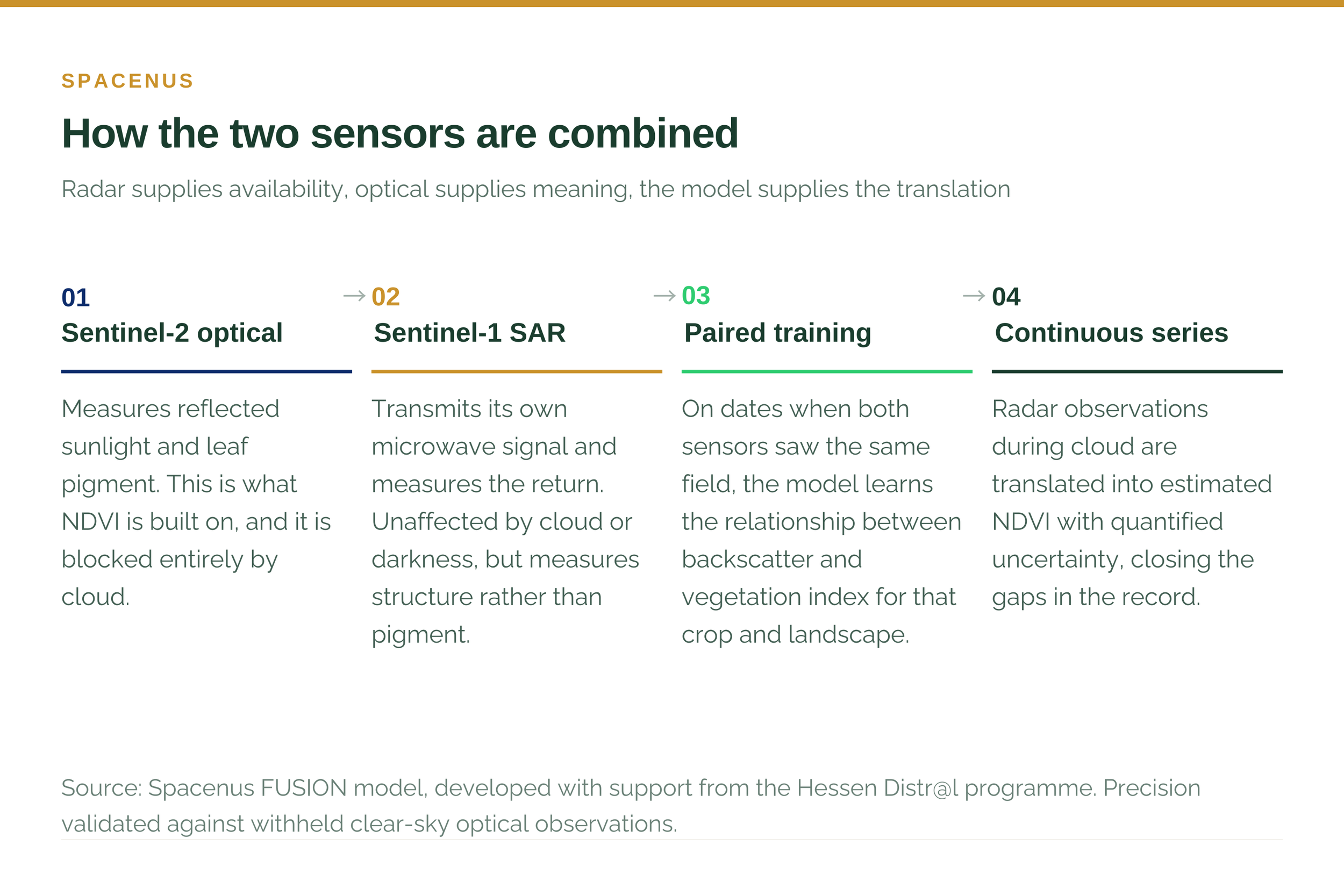
The result is a continuous time series rather than a scatter of usable dates. Our FUSION model, developed with support from the Hessen Distr@l programme, delivers greater than 90% NDVI precision through full cloud cover.
That figure deserves the same scepticism we would apply to anyone else’s. It is measured against withheld optical observations, dates where clear imagery existed but was excluded from training, so the model was predicting values it had never seen. We will supply the validation protocol on request, and a precision claim without one should not be accepted from us or from anybody else.
What continuity makes possible
Practice verification through the autumn and winter. Cover crop establishment and tillage timing are observable only if the series does not break during the months they occur.
Nitrogen recommendations at the right moment. A recommendation is only useful if it reflects the crop’s current state. Advice generated from a three-week-old image is advice about a field that no longer exists.
Geographies that optical monitoring cannot serve alone. South Asian monsoon regions lose four to six months of usable optical acquisition a year, which has kept satellite MRV largely out of rice and cotton systems.
Honest uncertainty. Because fusion is a model, its outputs carry error bounds that can be quantified and reported - unlike a gap, which carries no information at all and is frequently filled by interpolation without anybody saying so.
Where it does not help
Fusion is not a way of seeing through cloud. It is a way of estimating what was probably there, and the distinction matters.
It needs clear-sky periods to learn from. A field that is never observed optically cannot be calibrated, so the method degrades where it would be most useful.
The relationship is crop-specific and landscape-specific. A model trained on German winter wheat does not transfer to Punjab rice without local recalibration.
Estimated values are less certain than measured ones. They should be reported as estimates with error bounds, and a provider presenting fused output as though it were direct observation is overstating what they have.
“Fusion turns a gap into an estimate with a stated uncertainty. That is a large improvement on a gap, and it is not the same thing as a measurement.” — Spacenus team
Why this sits underneath everything else
Cloud tolerance looks like a technical footnote and functions as a precondition. Continuous monitoring, seasonal practice verification, and any credible claim to work in monsoon geographies all depend on it. A verification architecture that goes blind for four months a year is not continuous, whatever the marketing says.
FUSION underpins the field monitoring behind ANA and the practice verification in SatMRV. The methodology and validation approach are documented on our Science and Method page, and we would rather you interrogated them than took the number on trust.
Common questions
How much optical imagery is typically lost to cloud?
It varies substantially by region and season. Northern European winters and South Asian monsoon periods are the difficult cases, where usable optical acquisitions can fall to a small fraction of those scheduled for months at a time.
Is fused NDVI as good as measured NDVI?
No, and it should not be presented as such. It is an estimate with quantified uncertainty. The relevant comparison is not against a clear-sky measurement but against having no observation at all.
Does this work outside Europe?
The method transfers; the calibration does not. Each crop and landscape combination needs local training data, which is why the first season in a new geography carries a calibration cost the second does not.
Which satellites are used?
Sentinel-1 for C-band synthetic aperture radar and Sentinel-2 for optical multispectral imagery. Both are Copernicus missions with open data, which is part of why the approach scales affordably.