Reliable Fertilization Recommendation System: Outcome of 4-year ESA project
Background
To begin with, EU law sets strict limits on the amount of nitrate that can be present in groundwater. As a result, the EU fined a number of countries for failing to meet this environmental standard. At the moment, Germany is facing an insane fine of around € 861,000 per day due to groundwater nitrate pollution.
The use of excessive nitrogen fertilizer is also an issue in some countries. China, for example, consumes 400 kg/hectare of nitrogen fertilizer. Then there are countries like Africa that don't even bother. In Europe, nitrogen fertilizer is used at an optimal level of 185 kg/hectare, which is a good thing. It's been a problem for a long time if we look at it closely. Even though farmers use excessive amounts of fertilizer, which eventually destroys the climate, some soils simply cannot support high yields.
As a result, the main purpose of this project was to provide farmers and Agri-consultants with a simple and effective remote sensing-based tool that can help them precisely plan fertilization strategies. We had planned to build a WebApp that would provide them with legal information related to fertilization. It was our firm belief that if we could come up with a solution like this, we would be able to address the environmental challenges and agricultural losses caused by poor decision-making.

Challenges
It took about four years to complete the project. That vision became increasingly difficult to hold onto as the market changed. It was a multi-stakeholder effort that included farmers and agronomists as well as input manufacturers and space agencies. So, it was challenging for us to navigate through this complex ecosystem. It's important to note that this was a pilot project, so we needed to provide concrete evidence to reassure the stakeholders. It takes about three seasons to prove its reliability because the weather doesn't always behave in the same way. It was either dry or average, depending on the time of day. In order to test the tool in a variety of conditions, we had to use a variety of different procedures. An additional barrier had to be dealt with because of the ongoing pandemic. As we launched our first large-scale pilot project in 2020, we needed to meet with farmers face-to-face. We were unable to board them in the manner we had hoped because of the worldwide lockdown. We looked into online options to get around those roadblocks as an alternative. We set up a home office in order to keep in touch with farmers and other stakeholders. In fact, it was our goal to help the farmers whenever they reached out to us, even if it was outside of our normal business hours.
Second, due to an unrealistic assumption about us, we had to modify our model in the middle of the project. Farmers were instructed to take photos of their fields in order to improve satellite imagery calibration. Farmers with large fields, on the other hand, couldn't do it. As a result, we came up with a novel way to get the input of our users without requiring them to physically visit the fields.
In the early stages of plant development, recommending fertilization can be a real pain. To help farmers nourish their fields in the early seasons, we had to develop a new service called "Soil productivity map."
Major Findings
We discovered that farmers could save up to 8% to 15% of their fertilizer costs if they had access to our tool's information. Using our web app, the farmers were able to apply the correct amount of fertilizer at the right time, which resulted in a 1% increase in yield. Consequently, the landowners could reap a profit of around €28 per hectare thanks to more efficient fertilization, higher yield and a lower rate of plant lodging.
Finally, we realized that crop advisors play an important role in persuading farmers to use digital farming technology. Our product's efficiency would make it easier for us to break into the market if we could convince agronomists or crop advisors of its value. It would save us a lot of money if we didn't have to search for farmers. After that, we decided to target farmers through small and medium-sized businesses, which ultimately helped us commercialize our tool to the general public for revolutionary change.
We were able to reduce fertilizer expenditures by 80% of our users, indicating that we could successfully optimize fertilizer use. In addition, most farmers said they gained a better understanding of the health of their fields and crops than they had before.
Our remote sensing service is nearly identical to the service provided by field sensors, but ours is significantly less expensive. You’ll only have to pay a small sum of money upfront with our product.
That's all for now, but we're confident that our tool is the best way to implement the European Green Deal by allowing farmers to cut back on their fertilizer use by 20% without losing yield.
Achievements
In terms of numbers, we currently serve more than 100 farmers. We provide API services to four large and medium-sized companies. Between 2017 and 2019, we conducted a large-scale study in France, taking into account 4 million hectares of land. More than 90% accuracy in our prescribed recommendation for crops' nitrogen uptake was found in that study, and that's a huge accomplishment for us!
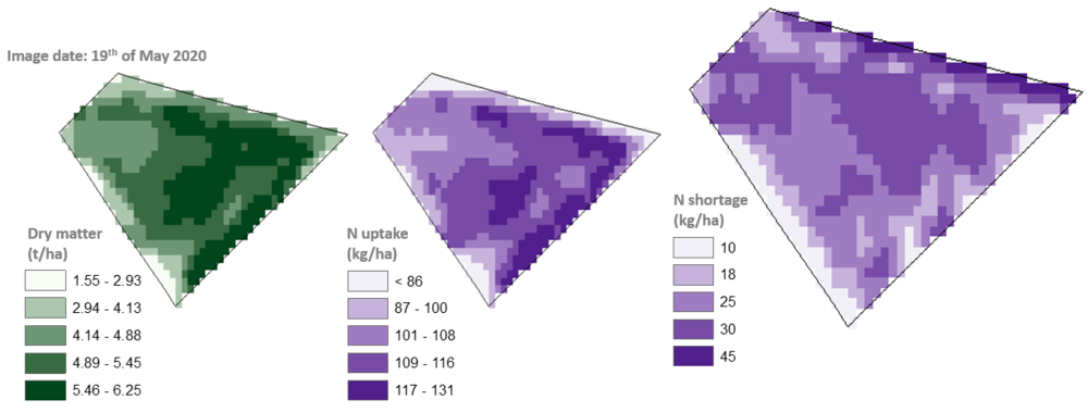
Figure: In this example, the plants experienced a deficiency of 25 N kg/ha n mid-May just before the third fertilization, also known as quality fertilization. In contrast, the absorption was 110 kg/ha with a 5.1 t/ha dry matter.
We made a strong showing in Germany as a whole. Different climatic zones, soil samples, and farm sizes were all compared and contrasted. Some countries had a high level of alleviation, while others had a low level. As a result, it was a test for us to see if we could overcome all of these differences and produce a useful model. Overall, more than 80% of clients were satisfied with the model's performance. Most of the users were satisfied with our tool, and we proved that ANA could save money and increase yield. The farmers gave it an 8.2 out of 10 rating, which is excellent for a prototype. In a nutshell, we were able to show exactly what ANA is capable of.
Partner Organizations
This project had a variety of partners. There were universities like TU Darmstadt and Justus Liebig Universität Giessen. In the field tests, they helped us out. To bring farmers and consultants to the table, we had K+S, a fertilizer manufacturing company, on our side. IAPN, a well-respected research institute, was one of the partners who demonstrated to us how certain fertilization strategies affected the growth of plants in a laboratory setting. All of this was made possible by the guidance of both the European Space Agency (ESA) and the German Aerospace Center (DLR).
Our Value Proposition
There are both measurable and intangible effects to our value propositions. Our primary value proposition is that Spacenus can help farmers save money on fertilizer and increase yields, which in turn improves their return on investment. All users would be able to see and hear it. Again, if Crop Advisors are expected to serve more farmers in a shorter period of time, a digital tool that flawlessly accelerates their work is unquestionably required. ANA and Field Map API services are a foregone conclusion in such a scenario. Additionally, our services help to maintain a healthy ecosystem in the vicinity. Using our tools, we can help ensure that agriculture is sustainable in the face of climate change. There will be fewer greenhouse gas emissions if we reduce the use of nitrogen fertilizers in the soil. To put it another way, the EU Green Deal would be much closer to reality if this happened.
Rollout and Commercialization Plan
Even before the development of our Agricultural Nutrient Assistant/ ANA, we conducted surveys. Farmer conferences in 2018 and 2019 saw us demonstrate a clickable prototype of the product. After seeing the prototype, they agreed to pay between €5 and €10 per hectare. We conducted additional surveys between 2019 and 2021 to come up with a satisfactory commercialization decision. In the end, we discovered that users are willing to pay an average of € 3-€ 5 per hectare of land.
Our product has two pricing options. Only 1 € per hectare of land must be paid for a specific type of map in the first option, which is called "Pay as you go." However, if farmers pay € 3 per hectare, they can use our maps throughout the year to better understand their fields. Then, farmers and crop advisors could access all of the precision farming maps, such as the Soil Productivity Map, Nitrogen uptake and shortage maps, various vegetation index maps, disease risk maps, and so on, for an entire year, as many times as they wanted, for just € 3 per hectare. They would be able to create farming maps in minutes with a few simple clicks.
As previously mentioned, there are corporate farms with their own platform. Our White Labelled API will allow them to use their own branding on the other side. As a result, we are able to offer the API services of ANA as well. For the sake of everyone's business plans, we've kept everything we could.
Final words
As a result of this project, we have already established that the users can generate an additional € 28 in profit per hectare of land-based on conservative estimations. Imagine if there were 300 hectares of land available for use. Users would pay € 900 for 300 hectares of land. On the other hand, in return, they would generate around € 9,000 additional revenues by simply adopting this precision farming tool. Finally, ANA provides financial benefits to its users, ensures food security, and promotes sustainable farming practices. This could be a real game-changer in the fight against climate change in the near future.